
Asia-Pacific E-Resilience Toolkit Tool
Earthquake Model Central Asia
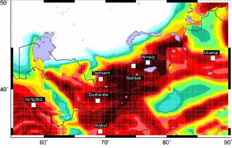
The Earthquake Model Central Asia (EMCA) is a Global Earthquake Model (GEM) regional program coordinated by the GFZ.
The EMCA (Earthquake Model Central Asia) catalogue includes information for 33620 earthquakes that occurred in Central Asia (Kazakhstan, Kyrgyzstan, Tajikistan, Uzbekistan and Turkmenistan). The catalogue provides for each event the estimated magnitude in terms of MLH (surface wave magnitude) scale, widely used in former USSR countries. MLH magnitudes range from 1.5 to 8.3.
Activities are subdivided into “Seismic hazard assessment and Microzonation”, “Seismic Vulnerability”, and “Earthquake Risk”. The catalogue includes the standard parametric information required for seismic hazard studies (i.e., time, location and magnitude values) and has been composed by integrating different sources (using different magnitude scales) and harmonised in terms of MLH scale.
The MLH magnitude is determined from the horizontal component of surface waves (Rautian and Khalturin, 1994) and is reported in most of the seismic bulletins issued by seismological observatories in Central Asia. For the instrumental period MLH magnitude was estimated, when not directly measured, either from body wave magnitude (Mb), the energy class (K) or Mpva (regional magnitude by body waves determined by P-wave recorded by short-period instruments) using empirical regression analyses.
The dataset is freely available for scientific use.


