Landslides and E-Resilience
A landslide is the movement of rock, earth, or debris down a sloped section of land. Landslides are caused by rain, earthquakes, volcanic eruptions, or other factors that make the slope unstable. Landslides can have severe consequences for people and critical ICT infrastructure in Asia and the Pacific. The E-Resilience Toolkit offers insights into a spectrum of available ICT tools and best practices that may benefit policymakers, DRM professionals and vulnerable communities in the Asia-Pacific region to enhance e-resilience and disaster risk management in the context of landslide hazard.
Displaying 8 - 14 of 38 tools and best practices relevant to landslide hazard.
-
An online resource to help mobile network operators join forces with NGOs rapidly and effectively in times of disasters.
-
The portable backpack-type mobile base station can be applied in disaster situations when communications networks are unavailable.
-
Google Person Finder is a web application that allows individuals to post and search for the status of relatives or friends affected by a disaster.
-
The Global Navigation Satellite System (GLONASS) is a space-based satellite system that can assist disaster rescue operations.
-
The Nationwide Operational Assessment of Hazards is a multidisciplinary research center with the goal of helping reduce the impacts of hazards.
-
The Beidou Navigation Satellite system is used to monitor natural disasters occurring in the Peoples Republic of China.
-
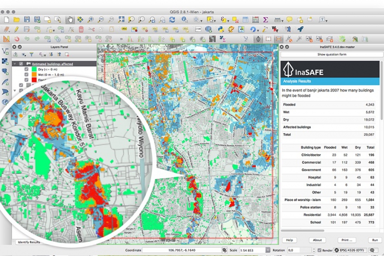
InaSAFE is free software that produces realistic natural hazard impact scenarios for better planning, preparedness and response activities.